Virtual satellite constellation tracks Yangtze turbidity
GA, UNITED STATES, September 21, 2026 /EINPresswire.com/ -- A virtual satellite constellation combining Landsat-8/9 and
Press Release Disclaimer: This is a press release distributed through the XPR Media network. It has not been independently verified by our newsroom.

GA, UNITED STATES, September 21, 2026 /EINPresswire.com/ — A virtual satellite constellation combining Landsat-8/9 and Sentinel-2 enables decade-long, high-frequency mapping of Yangtze River turbidity. It reveals climate-driven sediment increases on the Qinghai–Xizang Plateau and declining turbidity downstream associated with dams and ecological restoration, providing a practical framework for water-quality surveillance and basin management in other major rivers worldwide.
River turbidity reflects suspended particles and influences aquatic light conditions, contaminant transport, sediment movement, and ecosystem health. Yet field stations provide limited spatial coverage, while individual satellites revisit too infrequently to capture rapid river changes. Algorithms developed for lakes and estuaries also perform poorly in narrow rivers because of land adjacency, complex optical properties, and wide turbidity ranges. These limitations matter for the Yangtze, where climate change, hydropower development, urbanization, agriculture, and restoration measures are simultaneously reshaping sediment processes. Because of these challenges, in-depth research is needed to develop accurate, consistent, and high-frequency turbidity monitoring for large, optically complex rivers.
Researchers from the Nanjing Institute of Geography and Limnology, Chinese Academy of Sciences, the University of Chinese Academy of Sciences, Zhejiang Ocean University, and Jiangsu Environmental Engineering Technology Co., Ltd. published (DOI: 10.34133/remotesensing.1067) the study on July 1, 2026, in Journal of Remote Sensing. By integrating Landsat-8/9 and Sentinel-2 observations across the river’s mainstream, the team addressed a major monitoring gap: individual missions cannot reliably resolve short-lived turbidity changes or produce consistent decade-scale records along the narrow, environmentally diverse Yangtze River system.
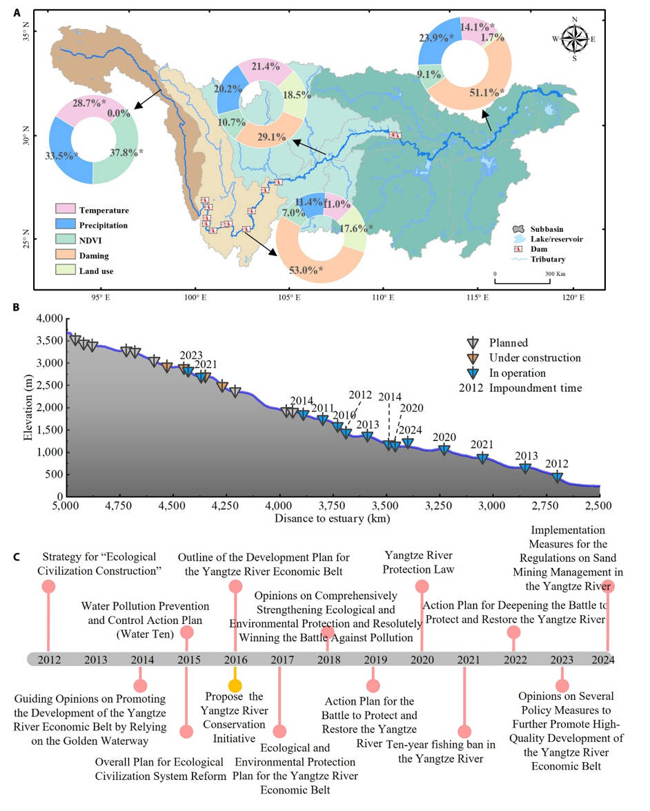
The researchers created sensor-specific support vector regression (SVR) models and harmonized their outputs at the product level. This design retained Sentinel-2’s finer spatial detail and each sensor’s distinctive spectral information, unlike approaches that resample all observations to a common lower resolution. The virtual constellation shortened average observation intervals to 2.5 days, compared with individual revisit periods of 5 to 16 days. It revealed opposing regional trajectories: turbidity rose strongly on the Qinghai–Xizang Plateau but declined through cascade reservoirs and the middle and lower river, separating climate-driven erosion from human regulation of sediment transport across the entire river basin over time.
For Sentinel-2, the SVR model achieved a coefficient of determination (R²) of 0.74 and a root mean square error (RMSE) of 16.62 Nephelometric Turbidity Units (NTU); Landsat-8/9 reached R² = 0.66 and RMSE = 17.74 NTU. Cross-sensor harmonization produced an average RMSE of 15.45 ± 13.43 NTU and a symmetric mean absolute percentage error of 12.53% ± 15.98%. From 2013 to 2023, mean mainstream turbidity was 67.75 ± 58.35 NTU, rising from 44.03 ± 43.76 NTU in the dry season to 79.93 ± 60.01 NTU in the wet season. Plateau reaches increased by 8.12 ± 5.51 NTU per year. Turbidity declined by 3.40 ± 3.17 NTU per year in cascade reservoirs and by 2.06 ± 1.04 NTU per year in the middle and lower reaches. Temperature and precipitation were the leading modeled drivers on the plateau, while dams dominated changes in reservoir and downstream reaches. The patterns show one river responding in opposite directions to climatic and human pressures.
“The virtual constellation helps distinguish where climate pressures are intensifying erosion and where engineering or restoration is suppressing sediment transport. This basin-wide perspective can support faster water-quality assessment and more targeted management, especially as further satellite missions become available and observation records grow longer and denser,” the team could state.
The team analyzed 6,265 Landsat-8/9 scenes and 25,118 Sentinel-2 scenes, together with 42,812 turbidity records from 61 monitoring stations. After atmospheric, glint, cloud, shadow, snow, and land-adjacency corrections, satellite reflectance was matched with field measurements. Six machine-learning approaches and eight established algorithms underwent five-fold validation; SVR performed best overall. Synchronous observations were empirically harmonized. Mann–Kendall tests and Sen’s slopes quantified trends, while a generalized linear model assessed temperature, precipitation, vegetation, dams, and land use as potential environmental and human drivers.
The framework could extend high-frequency turbidity monitoring to other large rivers, improve pollution-event detection, evaluate restoration policies, and strengthen evidence for Sustainable Development Goal indicators on aquatic ecosystems and water quality. Adding China’s Gaofen and HuanJing satellites could further improve coverage and stability. Future work should incorporate more physics-based retrieval models and nonlinear cross-sensor harmonization to reduce uncertainty. With these refinements, virtual constellations may become operational tools for reservoir management, sediment-risk assessment, ecological protection, and decisions across climate-sensitive river basins.
References
DOI
10.34133/remotesensing.1067
Original Source URL
https://spj.science.org/doi/10.34133/remotesensing.1067
Funding information
National Natural Science Foundation of China, grant numbers 42425104 and 42301422; Science and Technology Planning Project of the Nanjing Institute of Geography and Limnology, Chinese Academy of Sciences, grant numbers SKL2026-TJ10 and NKL2023-ZD01.
Lucy Wang
BioDesign Research
email us here
Legal Disclaimer:
EIN Presswire provides this news content “as is” without warranty of any kind. We do not accept any responsibility or liability
for the accuracy, content, images, videos, licenses, completeness, legality, or reliability of the information contained in this
article. If you have any complaints or copyright issues related to this article, kindly contact the author above.

Media gallery